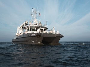
In August, the scientific research vessel "Mintis" of Klaipėda University will start research on the coast of Latvia in the Baltic Sea, which will carry out deep-sea mapping to help scientists study in detail protected marine habitats of EU importance, 1110 Sandbanks and 1170 Stony Reefs. "The dynamic marine environment and underwater landscape in Latvia's exclusive economic zone is still a mystery of the sea depths for us. The acquisition of new and accurate geospatial data is very important to ensure the protection of the values of the Baltic Sea. At the end of this year, we will receive the latest geospatial data of the marine research areas. Cooperation with universities and scientific institutes have an important contribution to the preservation of biological diversity. The specialists of the ship "Mintis" will carry out all the work together with the researchers of the Latvian Institute of Aquatic Ecology. Let's wish us all a calm sea in August," emphasizes Andrejs Svilāns, Director General of the Nature Conservation Agency. In the research areas of the project, the scientific research vessel "Mintis" of Klaipėda University will carry out acoustic mapping studies of surface sediments with multibeam echo and side scan locator. Based on mapping studies in the deep sea, Bathymetric maps and a map with classified surface sediment layers will be prepared. Works will be carried out at a depth of ten to sixty meters. This is one of the activities of the LIFE REEF project of the Nature Conservation Agency , which will be implemented in accordance with a tripartite agreement between the Nature Conservation Agency, Klaipėda University and the Latvian Institute of Aquatic Ecology.
Lai šī tīmekļvietne darbotos, tā izmanto obligāti nepieciešamās sīkdatnes. Ar Jūsu piekrišanu papildus šajā vietnē var tikt izmantotas statistikas un sociālo mediju sīkdatnes.